Description
The "Stolовая" mountain from the North
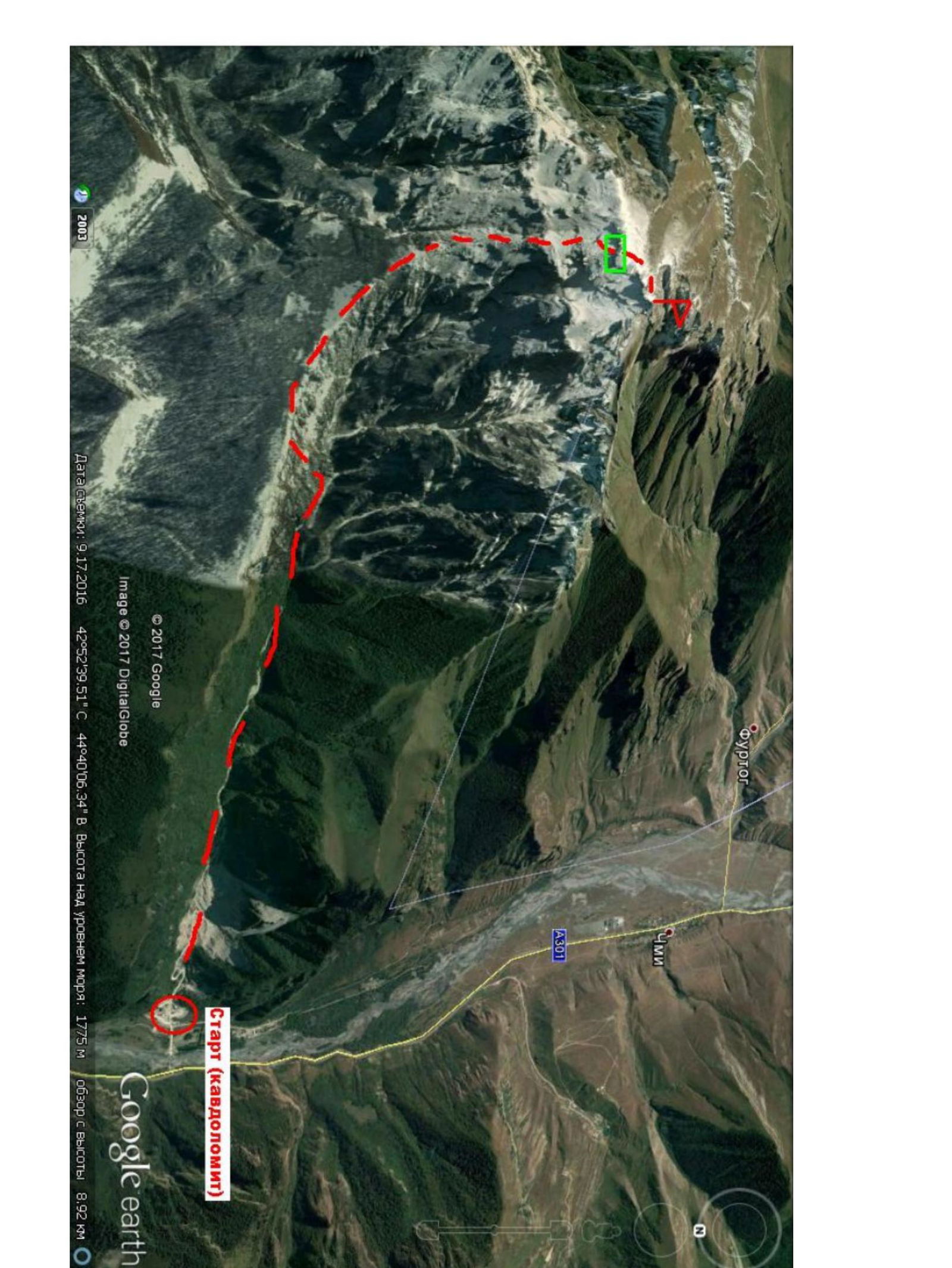
The route starts on the bridge over the Terek River between the villages of Balta and Chmi, at the mouth of the Vagai-choch (bear's) gorge. The bridge is controlled by an Interior Ministry checkpoint, where there is also a parking area. Passing through the checkpoint is free, but you need to have your identity documents (passport) with you.
From the checkpoint, follow the road east, leaving the "Kavdolomit" quarry to your right, without turning anywhere. Where the road ends, a trail begins, sometimes indistinct, along the bottom of the gorge, passing through the bed of a temporary water flow. The path is obstructed by:
- fallen trees,
- stone blockages,
- bushes.
The ravines are quite challenging. Over time, the gorge turns into a narrow canyon with smooth, sheer walls, and further on, the canyon widens again, with the slopes becoming gentler on the northern side.
You should continue until you reach a point where the trail branches off to the left, up the slope. From the checkpoint, it takes 3–3.5 hours. At this point, there is a fairly grassy, steep slope rising to the ridge, bounded on the east by rocks, along which the ascent to the ridge is made. The ascent from the valley floor to the ridge takes approximately 1 hour.
Follow the ridge east; there is a trail. Over time, the ridge turns to the right, transitioning into a steep, grassy slope with rock outcrops. You should follow the trail, trying to maintain a southerly direction along the gentlest part of the slope. Just below the "table" top, there is the route's "key" — a rocky belt, representing:
- an intensely fractured, crumbling limestone massif,
- about 30 m high (less than a full rope length),
- with a slope of about 40–50 %,
- wet during the off-season due to snowmelt, and in summer, after rain, due to infiltration.
At the bottom, the belay point is organized as needed; at the top, the rope is anchored to one of the "morcovkas" (rock anchors) hammered into the rock at the exit to the "table".
Time from the key to the summit:
- 4–4.5 hours.
After reaching the "table", you should move southwest towards the summit along a gentle slope.
Time from the key to the summit: about 30 minutes.
It is preferable to descend to the south, towards the village of Beyni (2–3 hours). Recommendations for the route:
- Start moving from the checkpoint as early as possible.
- Bring a hammer, pitons (including a couple of shovel-shaped ones), and ensure each participant has a jumar.
- During the off-season, if the ascent from the ridge to the key is slippery, it is advisable to move in a team on certain sections.
- If the route is snowy, it is advisable to bring crampons, at least 2 pairs per group.
StarG (Kavdolvit)
Since 2017 Google
Result: since 2017 definition
Executive Editor
Structural Editor
Structural Editor
Structural Editor
Structural Editor
Structural Editor
Structural Editor
Structural Editor
Structural Editor
Structural Editor
Structural Editor
Structural Editor
Structural Editor
Structural Editor
Structural Editor
Structural Editor
Structural Editor
Structural Editor
Structural Editor
Structural Editor
Structural Editor
Structural Editor
Structural Editor
Structural Editor
Structural Editor
Structural Editor
Structural Editor
Structural Editor
Structural Editor
Structural Editor
Structural Editor
Structural Editor
Structural Editor